
North Fork 25 Mile Creek
Chelan,
Washington
Overview
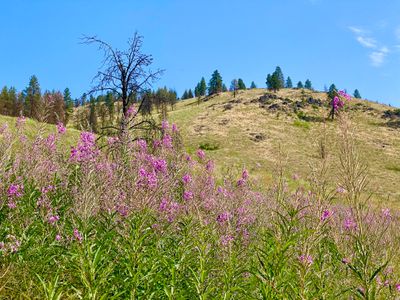
The North Fork 25 Mile Creek trail intersects with the Devil's Backbone Trail after 9.3 miles and over 4,000 feet of vertical gain and the full trail is typically done as part of a multi-day backpacking trip (or as a descent on a mountain bike). However, the lower section of the North Fork 25 Mile Creek trail makes for a great day hike, and is well suited to families. The first couple of miles have minimal elevation gain, and follow the creek through a mixture of forest and more open areas. The Lone Peak tail intersects at 2.25 miles, and can be combined with The North Fork 25 Mile Creek for a moderate hike.
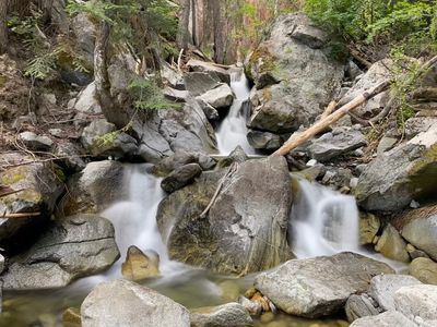
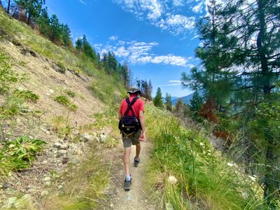
The trail begins a couple hundred yards up the road from the parking lot, and proceeds through open meadows with minimal elevation change on what used to be an old road. After little more than a mile in, you will enter a more forested area and reach the creek. Below is a small waterfall, and may notice some pipes which were used to send water to the Hale homestead a mile away. The trail continues along the creek, and has some short ups and downs. At 2.25 miles, you will intersect with the Lone Peak trail, and shortly thereafter the trail leaves the forest and then fords the North Fork 25 Mile Creek (no bridge) and there begins the majority of the elevation gain as the trail covers 6.5 miles on its way up to Crescent Hill.
Directions
Parking
Trip Reports
My parents were visiting and wanted to get out for a short hike with the dogs. Having hiked a short amount on the North Fork 25 Miles Creek trail while doing the Lone Peak trail in the spring, I thought that would be a new and interesting place for everyone to venture. We loaded up the extended family and dogs in the car, and made the drive around the lake and up to 25 Mile Creek. After parking next to the one other car there, we walked up Shady Pass Road to the trailhead.
I was hoping for a little more shade on the first section of the hike, but the first mile or so (including the walk up to the trailhead) had minimal shade. There was a decent breeze and it was mid-morning, so it was hot, but not stifling. The grass, weeds and bushes were starting to encroach on the trail. It didn't bother me, but my son was having some issues with prickly weeds rubbing against his legs.
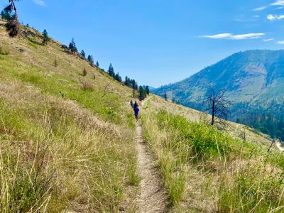
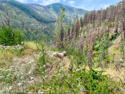
The trail crossed a dry stream bed, and then made it way through a partially burned out forest - not sure which fire this was, maybe the recent 25 mile creek fire, or possibly the older Pot Peak fire in 2004. Some trees had escaped the worst of the fire, and did provide occasional shade along the way.
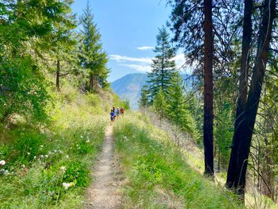
At about a mile in, we entered into some thicker forest and the trail descended down close to the creek. From what I have read, the trail follows a very old road and at this point the road ends. While it wasn't immediately obvious to me that we were on an old road, the trail definitely changed at this point, no longer flat and open.
About fifteen feet below us, there was a small waterfall, and my dad, son, two dogs and I descended off the trail and down to the water, with my mom and wife opting to watch us from the trail. The dogs drank water and sat down in the pool below the small waterfall, enjoying the cool mountain water.
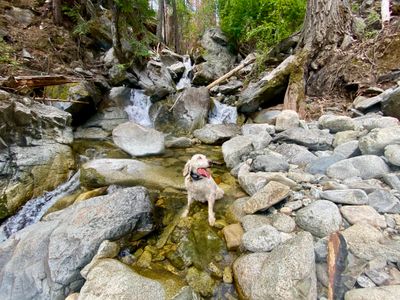
My parent's older dog Gem, almost 12 years old, had a hard time getting back up to the trail, so I had to lift her up a couple of times over rocks. My back had already been bothering me from some landscaping work around the house, and later that day I was really feeling the effects of picking her up. I guess I need to lift with my knees and not my back!
We decided to turn around here and head back. The trail in front of us went up steeply, and I went up a little to see if it leveled out, which didn't appear to be the case. On the map there isn't much vertical gain, but it does look like this small section has more up and down than what we had come in on. Upon leaving the water, I noticed some old metal pipes, and later learned that apparently this was constructed in 1945 as a water source for the Hale Homestead, which makes sense as to why there would have been an old road to this point.
The hike back out was straightforward. We had to keep reminding the dogs, especially Gem the older dog, not to venture down the steep hillside in search of wildlife. They are bird dogs, and once they catch a scent of something interesting, its hard to get them to back off.
It was a short, but fun hike. It's quite a drive from Manson, but my parents had never been in 25 mile creek and the drive itself is very pleasant. I have now done some bits and pieces of the trail, and need to figure out how to do the full trail, either as a multi-day or let the back get better and slog out the 18 miles in one day.