
Lone Peak
Chelan,
Washington
Overview
Lone Peak trail is a bit of an oddity. The trailhead is located on the side of Lone Peak, but rather than climb up to Lone Peak, it descends down into the North Fork of Twenty-Five Mile Creek for 1.25 miles at which point it ends by intersecting with the North Fork Twenty-Five Mile Creek trail. And it's not like the Lone Peak trail shaves off a ton of mileage, as the North Fork Twenty-Five Mile Creek trailhead is a little over 2 miles from the intersection. Perhaps it was meant more for mountain and dirt biking, or put in as a way to access the river for those looking to camp at Lone Peak campground?
That being said, it's a nice hike down to the river, with pleasant views of the valley, and one can continue along the North Fork to further the hike. An alternate option would be to hike the North Fork Twenty-Five Mile Creek trail, and then proceed up the Lone Peak trail and turn around at the trailhead, providing a little over 6 miles and a more typical hike that doesn't start with a descent.
Directions
Parking
Trip Reports
This trail had piqued my interest, as I couldn't really figure out why it existed - it is super short, all downhill and it's not like the trailhead is close to anything of significance. But I can't say I came up with a definitive reason on why the trail was put in after hiking it. Maybe for some downhill mountain biking? It looked like there may have been an official Lone Peak Campground at some point, so maybe the trail was put in to serve the campground?
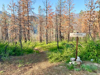
Anyways, it turned out to be a nice hike on a warm and pleasant day. The trail starts slowly descending through some burned out trees with nice views of the valley. A couple of switchbacks later, and the trail straightened out but kept on descending. It looked like there may have been some motorbikes on the trail at one point, but the tracks looked to be pretty old and mostly washed out.
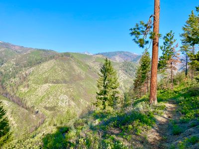
I could still see a little snow on Stormy Mountain and Devil's Backbone, but with the temperatures consistently in the 80's recently, I doubted that snow would stick around for long. The trail itself was in pretty good shape, considering it probably doesn't see a lot of use, with no blowdowns or overgrown spots. After a little less than a mile, I could see the North Fork of Twenty-Five Mile Creek in the valley below.
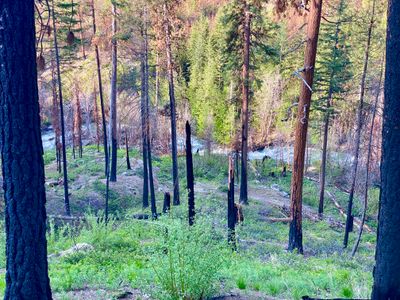
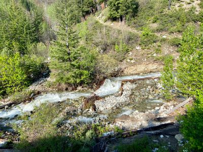
Before I knew it, I reached the junction with North Twenty-Five Mile Creek Trail, and decided to go down to the river bank and snap a few photos. The river was raging with all the new snow melt. Not content with turning around at this point, I started hiking up the North Twenty-Five Mile Creek Trail.
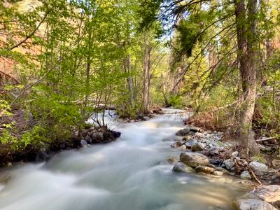
The North Fork Twenty-Five Mile Creek Trail was really nice - it meandered through the forest along the banks of the creek, and there were a number of wild flowers in bloom. After a little over a half mile, the trees disappeared and shortly thereafter, the trail cuts across the creek and heads up another drainage. There was no bridge over the creek, and while it looked possible to ford, I didn't feel like getting wet and decided this was a good turn around point.
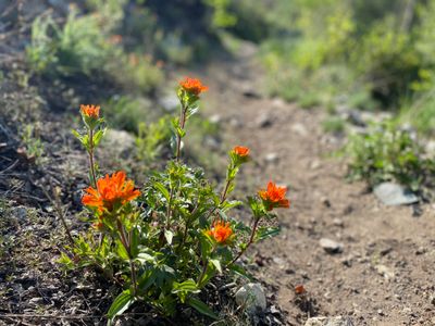
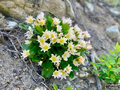
On my hike back down North Fork Twenty-Five Mile Creek Trail I noticed some pretty wildflowers that I had somehow missed on the hike up : Siskiyou Lewisia and Applegate's Indian Paintbrush. I had never seen Siskiyou Lewisia before, it was quite stunning.
Reaching the trail junction, I turned off on Lone Peak trail and made my way up to the trailhead. I think next time I do Lone Peak trail, I will start at the North Fork Twenty-Five Mile Creek Trailhead, and then turn around at the Lone Peak Trailhead.