
Coyote Loop
Chelan,
Washington
Overview
The Coyote Loop is .7 mile loop on a plateau above the Chelan river and is accessed from the end of the Eagle Trail. While the loop itself is only .7 miles, the total mileage is about 3.8 miles, as you will hike along the Reach One trail and Eagle Trail to reach the Coyote Loop. None of the trails in the hike have any shade, so it's best done in the mornings during the summer (not to mention rattlesnakes will be less likely to be out), and makes for a great wildflower hike in the spring.
From the Chelan Butte trailhead, follow the Reach One trail for .4 miles, and then take the Eagle Trail for 1 mile at which point you will arrive at the Coyote Loop. I recommend hiking the loop counter clockwise so you can enjoy the view over the river at the end of the loop.
Directions
Parking
Trip Reports
With summer travel, enjoying the lake and some occasional mountain biking around Echo Ridge, I hadn't been out on a hike in the Chelan Valley for a couple of months. I had some errands to run in Chelan on Saturday morning before my son's soccer game, and I decided to sneak in a quick hike on Coyote loop before doing said errands. The mornings were starting to cool down, and I was looking forward to checking out this new area.
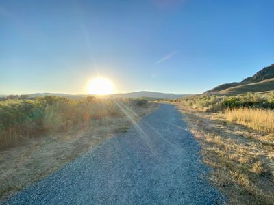
Pulling into the parking lot at 7:30am, it was busy - at least for Chelan - with about five cars in the lot. It sounded like a group of folks were getting ready to head up Chelan Butte. I grabbed my gear and made my way down the Reach One trail, watching the sun rise above the horizon.
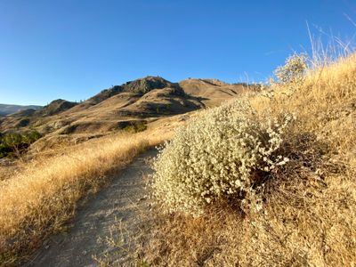
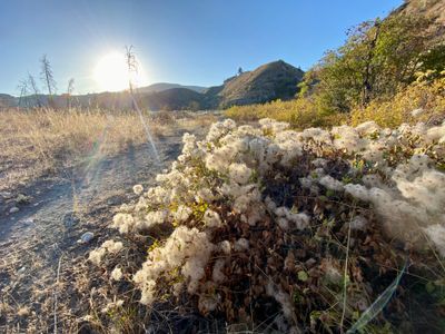
After less than a half mile, I turned onto the Eagle trail. Although the wildflowers of the spring and early summer were gone, there were a number of plants with interesting blooms. It's so dry around here I wouldn't think many plants could have flowers in the late summer, but I suppose they have to adapt in order to survive. While not nearly as impressive a display as the spring with way more muted colors, it was interesting nonetheless.
I passed by the start and then the end of the Cutthroat Loop, and shortly thereafter began a small climb up out of the river basin. When I had done the Eagle Trail with my son earlier in the spring, we had turned around at the Cutthroat Loop, so this was new territory for me.
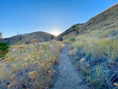
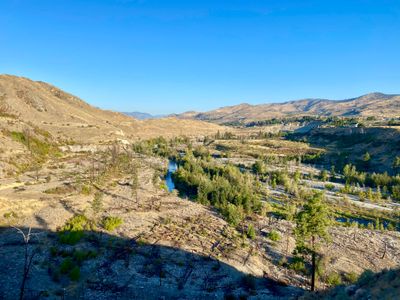
Reaching the end of the Eagle Trail and start of the Coyote Loop, I decided to head counterclockwise, which in hindsight was the best direction, as it saved the nice view until the end of the hike. I noticed a couple of mountain bike tracks on the trail. Not sure if I hadn't seen them on the Eagle trail, or if they came in from the Gorge Road.
I continued along the trail, which had flattened out by this point. A little less than halfway along the loop the trail made its way along the bottom of a ridge, which provided some shade and cooler temps. Which was fortunate, because I was startled when I saw a rattlesnake curled up just off the side of the trail. I jumped back when I saw it, but quickly regained my composure when I realized it was still asleep (or it was too cold for it to be active). I quickly snapped a picture and kept hiking.
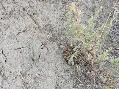
Fortunately, I didn't see any more Rattlesnakes after that encounter. A couple hundred yards from the end of the loop was a nice vista over the river basin. I completed the loop, and then headed back down the Eagle Trail.
I made my way back to the car and was surprised to see it had taken me under an hour and fifteen minutes to complete. With the cooler weather I hadn't bothered to stop and hydrate. It was a nice hike, although if you are short on time or looking to shave off the mileage, you can just stick with the Eagle trail and then proceed a couple hundred yards up to the view point.