
Journeyman Lodge
Whistler,
British Columbia
Overview
Journeyman Lodge is a full service backcountry chalet situated in the Callaghan Valley in the Coast Range about 15 miles northwest of Whistler at an elevation of 4,500ft. Callaghan Country, the company operating the lodge, has a special use sole permit for the valley, and provides mechanized transport (snowmobile, side by side or snowcat) to the lodge. Guests can also reach the lodge by skinning 8.3 miles of nordic trails.
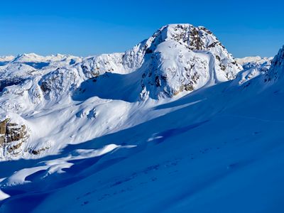
Callaghan Country and Journeyman Lodge are popular with nordic skiers, but it's also a great destination for ski touring with a large north facing massif that includes Journeyman Peak and Cal Pow. There is ample pillowed tree skiing above the lodge for low visibility days, and numerous alpine lines on the upper sections of the massif, including the Solitude glacier. With other objectives in the area as well, including Callaghan and Hidden Peak, there is and has enough terrain to keep one busy exploring for a week.
Directions
Parking
Trip Reports
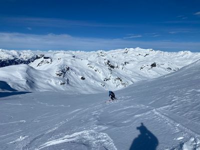
On our last day, we had the morning to ski tour and had to be back at the lodge a little before 2pm. The clouds had come in, and this was our worst weather day so far, although it wasn't particularly bad. Energy levels were not high - the rest of the group were continuing their skiing adventures in elsewhere in BC, and while I didn't have any more days of skiing, I was definitely feeling the effects of 5 consecutive days.
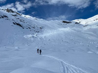
With two in the group, opting to stay back and rest in the lodge, the rest of us hit the nordic trails and made our way over to the skin track. Given the limited visibility and time constraints, the plan was to stick to the trees and try and find some less skied out areas on the lookers left hand side in Shade Glade.
Trevor opted to cut a new skin track up through the trees, as the old one we took a couple of days ago was worse for the wear. Once above the trees, we headed up into the alpine high enough to be able to ski over to our run.
The ski down was actually pretty good. Visibility was better than expected, and the snow was fairly consistent. I had forgotten my boot inserts, and felt like I was in the backseat on the ski down, it may have more been my tired legs.
Upon reaching the trees, Trevor realized we were above some very steep terrain that wasn't skiable right now. We made our way over skiers right and then descended through the trees to the bottom. Unfortunately, this area had been skied prior, and the snow was quite chopped up. With steep treed slopes, choppy snow and tired legs, it was survival skiing.
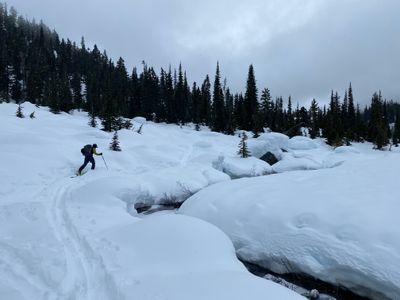
At the bottom, we had to skin back north along the river to reach the only standing snow bridge. Sounds like in a normal year, there would have been other options to cross the river and take a more direct approach back to the lodge.
Had some fun skiing in the top part, and I'm glad I got out for the final day, even though it was short and not as fun as the preceding days. The trip was great, and I highly recommend checking out the lodge - lots of fun terrain, and the accommodations were great for a backcountry lodge.
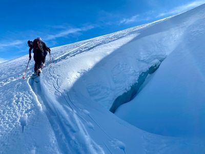
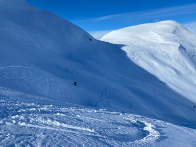
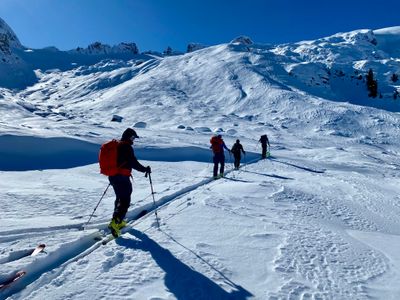
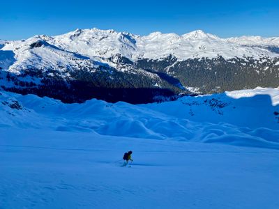
The original forecast had been calling for more clouds and light snow, but that never materialized, and we woke up to blue skies on the 19th with nary a cloud in sight. It was time to head up the solitude glacier and hopefully catch some fantastic views of the coast range.
We followed the skin track from Day 2, and broke off to get onto the solitude glacier. The local beta indicated crevasses weren't a concern during winter travel on the solitude glacier, even during this low snow year, and hence, we didn't have to rope up. With the sun glaring down on us, it felt like a spring tour!
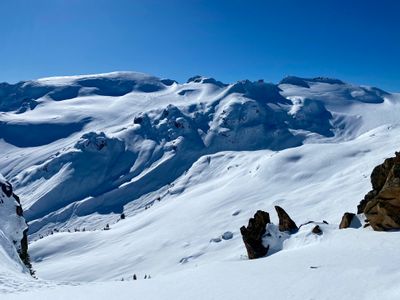
We encountered our first snowmobile tracks of the trip on the solitude glacier, frozen into the snow below us. They seemed to come out of nowhere, given the surrounding peaks and ridges, but once up high, you could see there was a decent amount of mellow terrain, including huge ice fields off in the distance.
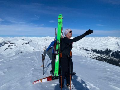
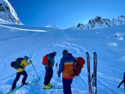
Like the days prior, as we headed higher the wind affected snow became more prevalent. And once fully on the wide open slopes of the glacier, there was very little loose powder. However, it was a beautiful day out, and we decided to head up to the top of nearby peak, CalPow. Near the top, the wind hammered unbreakable crust became difficult to skin on, and we switched to bootpacking.
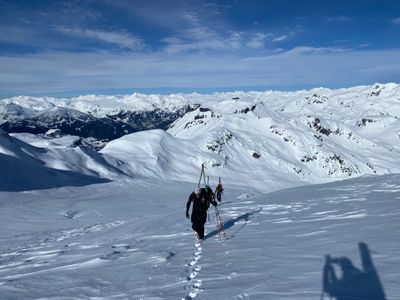
The views from the top were fantastic, as we could see mountains in all directions, including Whistler to the southeast and the Pemberton Icefield to the north. While I always marvel at the plethora of mountains when I'm in the north cascades, the coast range is on a different scale.
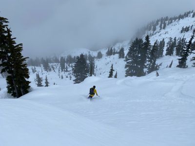
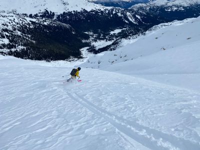
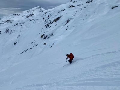
The ski down from the top actually proved to be better than expected. It wasn't great skiing, but the crust was smooth and solid, with no fear of breaking through, and it was straightforward to link turns together down the slope. Farther down, we had to pay attention to the snowmobile tracks, as they were frozen and it was a little jarring to ski across them.
Farther down we dropped into a nice short powder slope, and decided to do an extra lap.
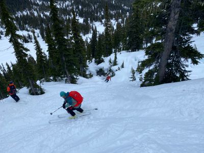
Continuing down, we were able to find more protected slopes with consistent powder, and enjoyed the turns down the mellow slopes.
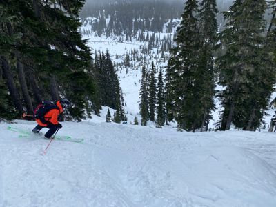
On the lower treed section, we headed skiers right this time instead of following our skin track. It proved to be a good decision with some nice powder lurking in the shade, and no other tracks. It was a little hectic with all of us skiing it at once, as it wasn't a big slope, but quite fun. Can't wait to check out my gropro video of that part.
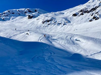
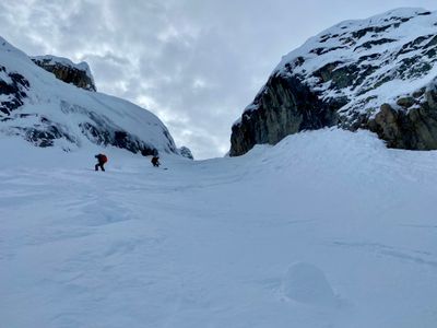
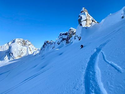
Day 3 had more clouds than the previous days, but visibility was still good up in the alpine, so Trevor decided we should head up and explore the North Shoulder of Journeyman Peak. Same routine as previous days lead us to the snowbridge, where we started heading directly up through the trees. The existing skin track was a bit challenging, as it was slippery and step in places, but otherwise it was an uneventful beginning to the day.
The conditions were the same as the previous days, highly variable with strong wind affected snow mere feet away from light powder, and then back to wind affected snow. Once above the trees, we followed our previous skin track from our day at the Gendarme for a bit, then broke off to head up Journeyman.
Higher up on the shoulder, any trace of powder disappeared. Discussion ensued about continuing to head up further, and we progressed a bit further up the route, before transitioning to ski mode. On the way up we had noticed some decent powder on a slope to our right, we could drop off the shoulder into a line that would lead us to that slope, and hopefully have some decent powder as well.
The top part was rolling terrain, and would have been very fun with the right conditions. However, consistent good quality snow was hard to find, with no sustained powder fields and lots of crust lurking around every turn.
We eventually skied onto the slope we had spotted while skinning up, and the powder here was more consistent, however it was a pretty small slope, probably only a couple hundred feet of vertical.
The final descent through the trees was mediocre. While there was no wind affected snow, it had been fairly heavily skied since the last storm. Certainly would be a fun place for storm skiing with lots of powder - it's fairly steep, well spaced trees and has a lot of features and pillows to play around on. Oh well, next time…
A shorter day for us, but I wasn't complaining as I was definitely feeling four straight days of skiing: three from Journeyman Lodge and one from Steven Pass on the way over.
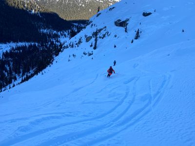
Day 2 on our ski trip, and we were already settling into the routine. After a quick beacon check outside, we skied down the cross country trail a bit until it flattened out, and then skins on to head to the only snow bridge across the river - due to poor snow year, as during a normal year there would be a number of natural snow bridges across the river. Our destination was the CalPow area, and we followed our exit from yesterday and started making our way up the valley.
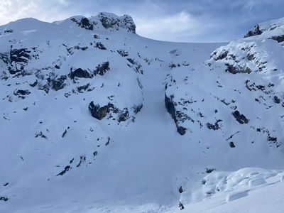
After ascending for a bit, we got a view of a nice couloir to our left, named Deep Throat. Not sure who named the runs in the area, but quite a few had sexual references, as later in the day we skied nocturnal emissions. There was a cool ice bulge in Deep Throat and it looked like a fun run, but there was also visible evidence of a slide, with avy debris scattered on the lower slopes.
As we skinned up through CalPow, we went through a short slope with consistent nice snow, which another group had recently enjoyed a couple of days prior. However, the higher up we went, the more wind affect we found, and eventually Trevor decided it wasn't worth going up any higher. We would ski Deep Throat, hopefully finding some decent snow.
Consistent powder eluded us, with variable conditions the theme for this run. While there were small pockets of powder, we had to ski defensively, as you never knew when you would run into a stiff breakable crust.
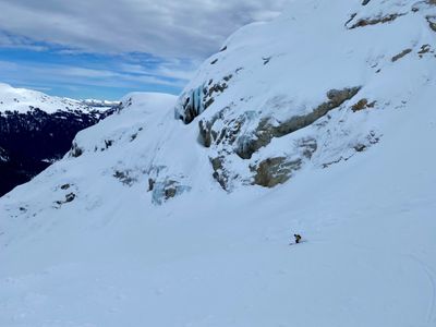
Within the couloir, there was less wind affected snow, however, there was also frozen avalanche debris to contend with. It was a fun aesthetic ski, and definitely worth doing, I just wish we had encountered better snow conditions.
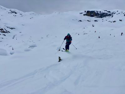
At the bottom, we decided to head back to our skin track and do some laps on the nice powder field we had skinned up through on our way to Deep Throat. It was on the smaller side, but we were all craving some consistent powder.
At the bottom, we all agreed to one more run. The powder was good, and there were some fun small little features to launch off - a relative term when every in the group is well over 40!
We skied down to the bottom, and followed the skin track out to the nordic trails and made our way back to the lodge, with enough time to enjoy a sauna and cold plunge before appetizers were served.
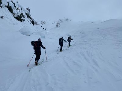
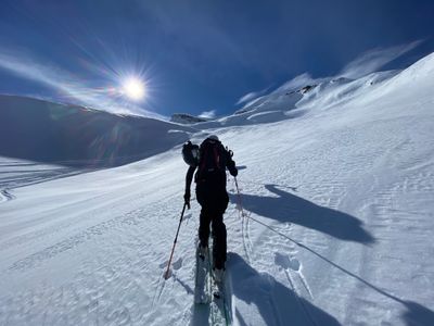
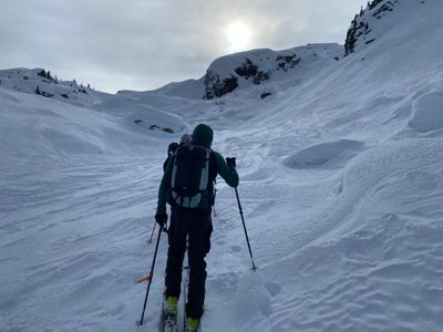
To celebrate Tyson's 50th birthday a group of six of us, including our friend and intrepid guide Trevor, headed up north to seek pow and big mountains during this challenging winter. We were the first group to arrive at the parking lot, and after filling out paperwork, four of us jumped in a side by side, with two on snowmobiles, and headed out to Journeyman Lodge. Once at the lodge, we discussed the plan for the day, and were skinning along the nordic track shortly after 10:30am.
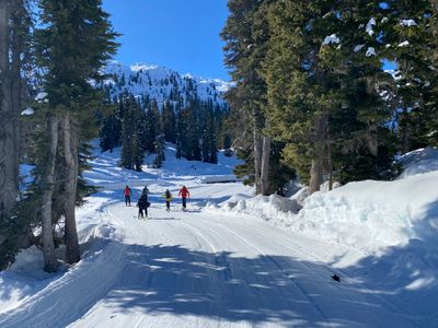
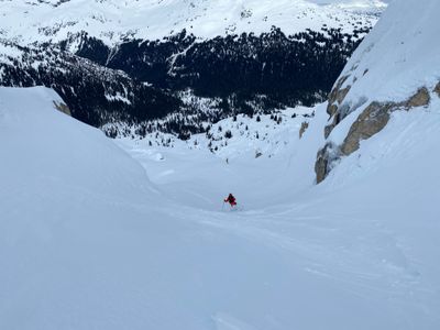
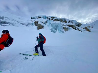
We planned to take advantage of the nicer weather and head up into the alpine into an area known as the Gendarmes, located on the large massif just south of the Lodge. We skinned west on the nordic trails and reached a snowcat made snow bridge to cross over the river - during a normal year, there were typically a number of natural snow bridges across the river, however, during this poor snow year, there was only a single snowbridge. Soon we exited the nordic trails and began our ascent up through the treed slopes and up into the alpine.
A couple of days prior there had been high winds, and the Gendarmes hadn't been spared. However, it wasn't remotely consistent, with pockets of loose powder mixed in with various levels of wind affected snow. I never saw so much variation, with drastically different snow mere feet away on the exact same aspect. We crossed our fingers and hoped Trevor would be able to locate some consistent pow for our first ski.
We topped out at a col around 6,800ft and had nice views south towards Powder mountain, on which we could see a number of snowmobile tracks. Fortunately for us, snowmobiles weren't allowed in the upper Callaghan Valley where we spent the next five days skiing, and outside of some tracks we encountered on solitude glacier, we didn't have to compete with any snowmobiles for fresh tracks...
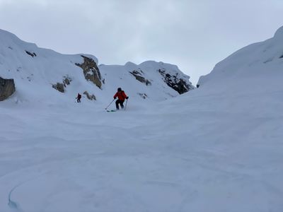
Trevor was able to locate some good snow for the ski down, with a good part of the run being old powder mostly unaffected by the wind. The upper section has some crust, but lower down we got into a more protected slope and enjoyed the turns.
We transitioned at the bottom and started heading up the slope and west. We had some discussion about trying to head over to check out a new area called Nasty Woman. It would require a fairly long traverse, and as we were headed in that general direction, we came across some nice preserved powder, relatively free of wind affect. Rather than try out luck on a new area, we decided to stay in the Gendarmes and harvest some pow.
The turns down the second run were great, with consistent powder down the almost the entire run. We skied until the slope mellowed out, roughly 800 vertical feet in total. Not a huge run, but enough for a fun ski.
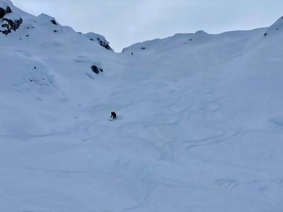
We transitioned again, and Trevor put in a new skin track back up to a notch in between our first and second runs. There was a gully further down we planned to hit that would lead us back to near our original skin track. The turns down the top section were good, not quite as consistent as the second lap, but still mostly powder.
The ski down the middle section was not particularly good - however, we knew what we were getting into as we had skinned up this section. While we were able to find some pockets of powder, it was very variable and for the most part survival skiing, with breakable crust lurking around every corner.
For the bottom section, we opted to head skiers left, as the skin route we took in the morning through the trees was skied out. The coverage was a little sparse, given the large rocks and pillows, but we were able to pick our way through the slope and connect back with the skin track at the bottom.
We made our way to the nordic trails and took them back to the lodge, arriving a little before the appetizers were scheduled to come out (5pm). All in all, a great day out in a new area. Nicer weather than expected, and fun to get up in the alpine and find some powder.