
Grouse Mountain
Chelan,
Washington
Overview
Grouse Mountain is a bit of a trek from Twenty-Five Mile Creek Sno-Park without the assistance of a snowmobile, but makes a fun objective in the area with moderate southern facing skiing off the summit. The northern side of Grouse Mountain drops towards the lake via Box Canyon and offers consistently steep slopes, however it can be tricky to find a suitable ski line due to trees, shrubs and cliffs.
For the most direct approach, follow the forest service road / snowmobile track from the Sno-Park and at the first switchback, head north through Darby Draw and past Lone Peak, and then trend northwest to reach the summit. Alternatively, you can follow the forest service road / snowmobile track to just below the summit of Grouse Mountain, however less direct and almost 7 miles. If you go with this approach, you do have the option to shave off some of the distance by heading north a little ways after the first switchback and connecting back up with the forest service road around 3,600ft.
Directions
Parking
Trip Reports
Having explored the areas around Echo Ridge, Antilon Sno-Park and Chelan Butte, Twenty-Five Mile Creek Sno-Park was the next obvious area for me to target. The snowy start to the winter had given way more moderate temps and a lot more sun recently, and the snowpack was diminishing quickly, but I was hoping the higher elevations around Twenty-Five Mile Creek would still have good coverage.
I did an alpine start, as I needed to get back to the house in time to watch the Super Bowl with my family. As my headlights illuminated the way up Shady Pass road towards the Sno-Park, I began to think I may have missed the window for this tour, as there was very little snow along the road and on the hillsides. In the dark, I couldn't get a good visual on the surrounding mountains, but this trip was not off to a promising start.
Arriving at the Twenty-Five Mile Creek Sno-Park, I could see a narrow broken strips of snow along the road that snowmobiles had been using, and decided to keep driving up past the Sno-Park. As I rounded the corner, the snowpack improved, with the entire road now covered in snow and I came up to a snow berm blocking any further progress. I backtracked to the parking lot, grabbed my gear, and walked along the road, putting on my skis once the snow became continuous.
A little ways past the snow berm I decided to leave the road and head directly up, as I was anxious to see what the coverage was like off the snowmobile track. The coverage was fine as I skinned up the slope. I also noticed some old ski turns etched into the snow - that was a promising sign.

Reaching the road / snowmobile track again, I eyed some slopes above with lots of exposed rocks and opted to continue along the road rather than take the more direct approach up Darby Draw. Even though the map indicated it was mellow terrain through Darby Draw, I was concerned I could run into bad coverage and be forced to throw my skis on my pack. Not something I wanted to deal with at the start of the trip.
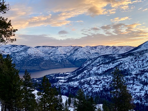
Skinning up the road was pleasant, but the snowpack was improving and I decided to cut off a switchback or two by heading northwest up the mountain. I caught my first glimpse of the lake not long after, and higher up was treated to a nice sunrise over Lake Chelan.
I had intended to hook back up with Shady Pass Road / snowmobile track, but on the way up came across a different old forest service road which headed towards Grouse Mountain and decided to follow it. There wasn't a snowmobile track on the road, but the snow was compact and it was easy skinning. I got a nice view of Lone Peak, as well as Stormy Mountain off in the background.

Eventually the forest service road came to and end, and I had another decision to make. Should I head up 400 vertical feet and connect back up with Shady Pass road, or continue along on the side of the mountain and take a more direct approach. The slope ahread had a good pitch to it, and sidehilling for a mile or so on hardpack without the assistance of a road didn't seem appealing - I would head straight up and connect back with the road.

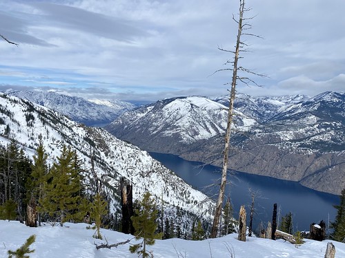
It was easy skinning along the road, but it felt like it took forever to finally get to Grouse Mountain. But I was making good time, and plan B kicked into motion. I would skin along the road past the summit of Grouse Mountain, and take a gander down the north side towards the lake and into Box Canyon. My hopes weren't high on skiing it, but I would kick myself if I didn't at least take a look.
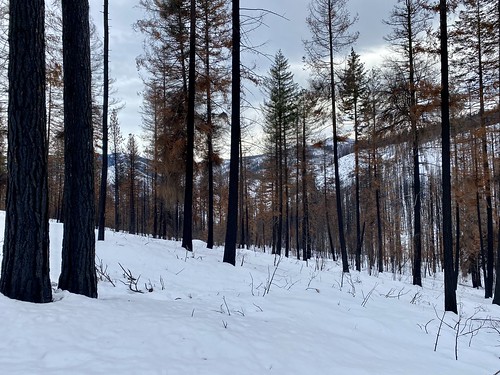
Again, it seemed to take a long time to reach my destination, but my energy level picked up as I left the snowmobile track and made my way through a mixture of trees and brush. As the slope started to descend, it didn't look promising. Although there were a couple inches of recycled powder, the slope was a mixture of brush and uncovered fallen logs. I couldn't give up this easily though, the thought of skiing even a lit bit was too tempting, given a little powder and nice views of the lake.
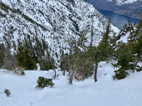
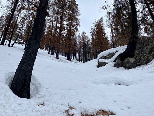
I skinned back up a little ways and proceeded east a bit, hopeful I could find something to ski. I finally reached a slope with some burned trees and a lack of bushes and decided to give it a go. I dug a quick pit on the slope, and found a consistent and well bonded snowpack below the couple inches of powder.
As I skied down through the open area, the slope steepened and eventually I descended into a stand of trees. They were spaced enough that I could link some turns together, but it was getting tight and the snow heavier. Surprisingly, it looked like I could have kept skiing down through some rocks and steep sections, but I decided to call it quits - I was pretty tired at this point, and needed to reserve some energy to ascend back up the steep slope.
This was my first skin of the year on somewhat exposed steep terrain. The snow was soft enough that I could get in a good track, but it took some energy and I was moving slow. As I made my way up and around, I crossed a couple of chutes that looked worth checking out in the future. I just have to make sure I'm in a little better shape, or get a lift on a snowmobile.
I was excited to reach the ridge and get eyes on the official summit of Grouse Mountain. Once at the summit, I took a nice long break and enjoyed the views. I was tired, but definitely glad I had done a short ski down the north side towards Box Canyon. I was still good on time, and while I knew I would have to do some traversing on the way down, I was hoping it was skiing all the way back to the car from this point.
The turns off the top of Grouse Mountain were nice, with open slopes and consistent edgeable hardpack snow. Upon reaching Shady Pass Road, I decided to follow the groomed snowmobile track a little ways to the east, positioning myself for more of a direct ski into Darby Draw. On the way over a group of four on sleds motored past me. It was the first sign of snowmobiles all day - I thought maybe I had heard some earlier, but it was so faint I couldn't really tell.
I found a spot that looked reasonably open below and began my descent towards Darby Draw. As I descended down the slope, I noticed a lot more bumps in the snow, likely due to the shallow depth of the snowpack not covering up the brush and logs buried underneath.

Farther down I found a nice creek bed to ski down, and eventually the slope started to flatten out, and I began to traverse through Darby Draw. The forest was pretty open, with evidence of a recent burn and I was able to keep progressing without exerting much effort. Despite my concern in the morning about bare spots, it would have been easy skin up through this way.
Eventually I came out of the forest, and was on an open slope a little ways above Shady Pass Road. My legs were shot at this point, so I slowly skied down into the road / groomed snowmobile track and skied it back towards the car. I took off my skis once the snow ran out and walked a little ways back to the Sno-Park, still with plenty of time to make it home, even with a grocery run in Chelan!

Definitely glad I got out on this tour and was able to ski the north side, even with the time constraints of getting back in time for the Super Bowl. Heading directly up Darby Draw would have been a shorter approach, and one I will do next time. Also excited to check out Lone Peak, it's less mileage and could make for some fun turns on a powder day. Now I just need to get a sled so I can more easily explore the north side of Grouse Mountain some more!