
Antilon Overlook
Manson,
WA
Overview
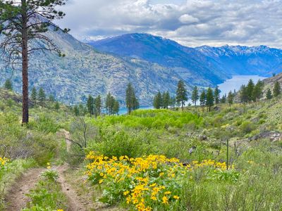
If you are looking to get outstanding views of Lake Chelan, and don't feel like the uphill on the nearby Fourth of July Mountain hike, this hike will take you around and through a large grove of quaking aspen before delivering on the views of Lake Chelan. And during the spring, you can expect wildflowers galore in addition to views of the lake. This isn't an official hiking trail, rather the remnants of what looks to be an old forest service road, and access is a little tricky (see below on directions) and there is no signage.
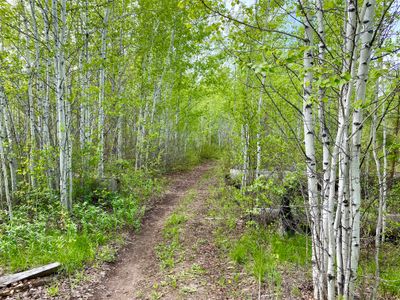
If starting your hike from Antilon Lake Campground, follow the faint trail which wraps around Upper Antilon Lake until it reaches a road. Follow this road for a couple of hundred feet until it intersects with Antilon Spur Forest Service Road, and take a left to begin the hike. The hike begins on Antilon Spur Forest Service Road 8200-115 next to Upper Antilon Lake, and the road quickly becomes overgrown in spots as it heads away from Lake Chelan (east and south ) before turning west through an aspen grove. In less than a half mile you will have full views of Lake Chelan, and after descending a bit and heading downlake, there is a nice ridge off the road that provides a great turnaround and break spot. While you can follow the road further, it continues on into Emerson Acres.
Directions
Follow the Grade Creek Road for 3.5 miles (pavement ends about 1.7 miles in), and if parking at Antilon Campground, take a left into the campground and follow the road (always stay right) down to the lower outhouse. Find a place to park and look for the connecting trail at the western edge of the road near the lake. If heading to Antilon Spur, follow Grade Creek for a couple hundred yards and take a left on Antilon Spur Road. Follow the road as far as you can, and find a suitable place to pull over.
Parking
Trip Reports
While on a ski tour on Fourth of July Mountain, I had come across a cool rock overlook on the bottom of my descent, and had then followed a snowmobile track out towards Grade Creek that looked to be on some sort of road. Looking at satellite photos showed faint outlines of a road, and I made a mental note to go back and explore once the snow was gone - it looked like it could be a fun hike to bring the family on.
As I pulled onto Antilon Spur Forest Service Road, the thought quickly crossed my mind that I might be better off pulling off on Grade Creek Road and walking down. The road didn't look that bad, but it was overgrown in spots and certainly didn't look like there was an option to turn around if things got ugly. But throwing caution to the wind, I continued down the road. Eventually I came to a short spot that was steep and rutted out, but I was able to get my Subaru down without bottoming out and I found a place to pull over and begin the hike.
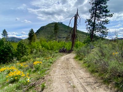
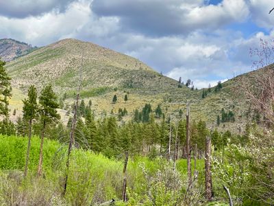
The road was obstructed by numerous hanging tree branches as it crossed a small dry gully, and on the other side it started heading east away from Lake Chelan. I had a nice view of the slope I had skied on Fourth of July Mountain, and eventually the road started heading west toward Lake Chelan through an aspen grove, which I had gone through on my ski tour.
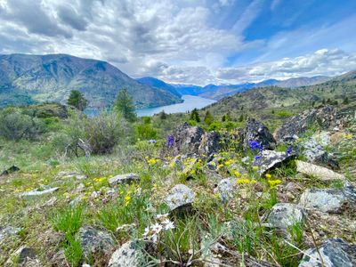
A short while later, Lake Chelan came into view and it was quite the site with the wildflowers still in bloom in the area. The road was starting to look more like a trail at certain spots, but in general the two tire tracks were fairly well defined. In addition to some recent mountain bike tracks on the road, I did notice some other tracks that might have been an ATV or side-by-side. While I hadn't heard of this road/trail before, it obviously gets some use.
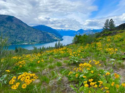
The trail began gently descending, and then a bit further down, started to trend more south and downlake. I noticed a small rocky ridge coming off the road, and ventured off the road and onto the ridge to snap a couple of photos. I was tempted to sit down and enjoy the scenery, but had plans with my family, and had to quickly turn around and start making my way back.
It was a little over a mile back with minimal uphill and the hike went by fast. Across the valley I could see slopes covered in arrowleaf balsamroot flowers. Even though it was far away, the slopes were bright yellow, and I tried to get some photos of them, but it was hard to capture.
Back at the car, I was able to turn around and make it back up the rutted out section without issues. I ventured over to Antilon Lake Campground to quickly see if it was possible to link up with this hike and found a faint trail that connects into the road. Excited to take the family on this hike in the near future, and I will probably park in Antilon Lake Campground this time, although my son might have fun driving down Antilon Spur road.