
4th of July Mountain
Manson,
Washington
Overview
This is definitely one of the better hikes in the Lake Chelan area, rewarding hikers with outstanding views of Lake Chelan from the top. This hike is a 20 minute drive from “downtown” Manson, and would be easy to pass by with an unassuming trailhead a ways off the road, no real parking lot to speak of, and few visitors.
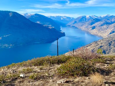
The start of the hike begins once you cross the Lake Antilon dam, and quickly begins ascending through the forest. You quickly exit the forest and traverse along the side of Fourth of July Mountain until reaching a ridge, at which point you will catch your first views of Lake Chelan. As you progress up the ridge, you’ll have better views of Lake Chelan, as well as Wapato, Roses, and Dry Lakes. Upon reaching the top, proceed a little farther north for expansive views of Lake Chelan.
Directions
Parking
Trip Reports
It had been awhile since I had hiked Fourth of July Mountain, over two years in fact. I had ski toured up the mountain a couple times this past winter, but was looking forward to getting out for a quick fall hike after work.
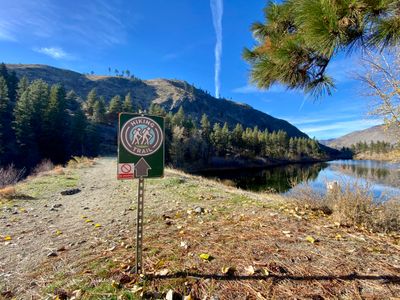
As expected, there were no cars parked along the side of the road. Walking down to Antilon Lake I noticed they had put in a new sign indicating the trailhead was up ahead. Probably a good thing, as I remember being uncertain if I was in the right area the first time I did this hike.
It was a nice fall day and given my late start, I was hoping the sun wouldn't dip behind the mountain during my hike, as it was keeping the temperature comfortable.
Soon I was hiking up the ridge and feeling a bit out of shape, having to slow down on the steeper parts. I hadn't been on any decent mileage hikes in awhile, and my jogging had been sporadic. This hike would help, but probably not enough to be in good shape for the fast approaching backcountry ski season. I took a couple of quick breaks to enjoy the views, telling myself it was for the opportunity to take photos and some video, not because I needed the rest...
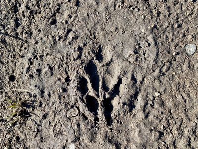
As I continued up, I noticed a paw print in the trail, which I'm guessing was from a coyote. It had rained a couple of days prior, and the trail had no prints from either human or other animal up to this point, so I don't think it was a dog. On my ski tour last winter, a coyote had casually sauntered past me less than a hundred yards away.
A short while later, I reached the summit. I had covered 1.5 miles and 1,200 vertical feet in 45 minutes, which made me feel better about having to slow down on the steeper parts, as that was still a pretty good pace for me. I continued down to the north side and found a nice log to sit on and enjoy the views uplake.
The peaks in the background had a decent covering of snow. There had been snow falling at my house earlier in the month, but nothing stuck around the lake. Far off in the distance I could make out Pyramid Peak which looked like the top part had enough snow to ski.
After a nice break, it was back up to the top and then a quick hike down. Reaching the car, I was surprised to see another car nearby, with a couple getting ready to do the hike. Crowded day at Fourth of July Mountain!
Intial impressions wouldn't lead you to believe this trail is the best day hike around Lake Chelan - there is no signage indicating a trail exists, nor is there a parking lot. But the views at the top more than make up for the humble beginnings.
After finding a place to park along the road, I walked along the dam and noticed a metal structure protruding from the surface of the lake. Antilon Lake was constructed in the early 1900's as an irrigation source for the region, and I'm guessing it may actually be a reservoir rather than a lake. Anyways, whether entirely built by man or not, the view was pretty and the stiff breeze coming down the lake was nice, as my late start in the day caused concern the heat might take a toll on me.

At the end of the dam I encountered the offical trailhead and my hike began in earnest. The trail quickly started gaining elevation, while the breeze from Antilon Lake kept me cool.
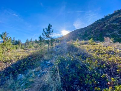
The trail is well kept and easy to follow, however it's not wide like some of the trails I have recently been on in the I-90 corridor. The dust I kicked up hiking lingered in the air as the recent breeze all but died. As I progressed up the steady incline, I felt the afternoon sun beating down on me and sweat pooled around my forehead and hoped I was close to reaching the ridge.
As I approached the ridge, a group of deer eyed me nervously. But continuning along the trail, they lost interest and went back to grazing on the grass and shrubs. It still amazes me how often I see deer while in the Chelan area.

At about ¾ of a mile I reached the ridge and caught my first view of Lake Chelan. I didn’t bother stopping to soak in the view, as I knew the views would be much better as I continued ascending the ridge. And my hope was the top would provide great unobstructed views of Lake Chelan.

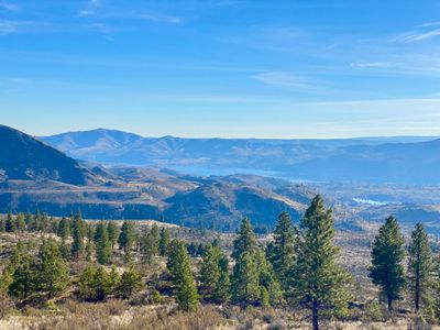
All four lakes, Wapato Lake, Roses Lake, Dry Lake and of course the star of the show, Lake Chelan, came into view as I continued hiking up the ridge. The green agricultural land around Manson provided a nice contrast with the dry scrubland in the foreground.

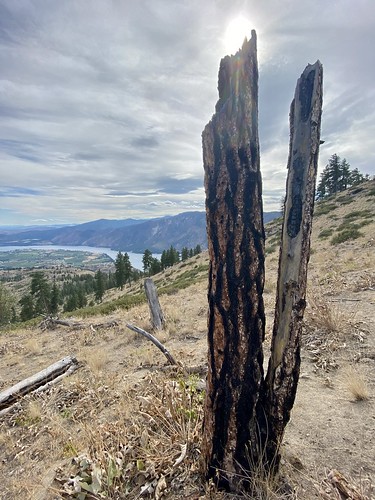
There was evidence of fires in years past with scorched trees and shrubs all along the hike. In 2016, the Antilon Lake fire burned 315 acres before being contained. Remnants of fires are a common sight all across the Eastern Cascades, and unfortunately, not something that is likely to go away anytime soon.
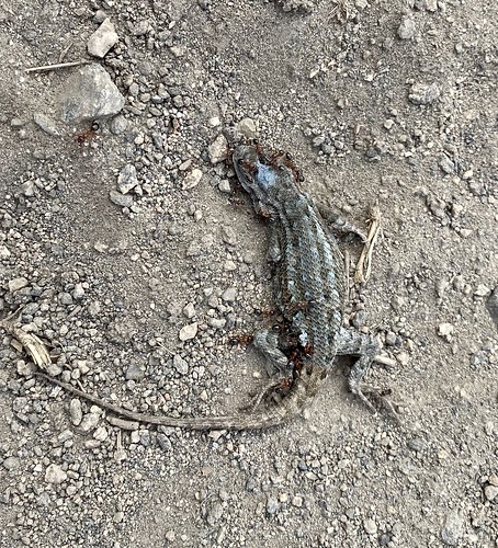
During the hike, something scurried by my feet and startled me; I quickly jumped out of the way before realizing it was just a small lizard. The lizards continued to suprise me along the hike as I never really got used to the quick movement at my feet. I had hoped to snap a picture of one of the lizards, but they were too fast and quickly ran away. I did come across a dead lizard in the trail and used the photo to later identify it as a Western Fence Lizard.
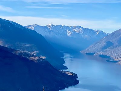
I reached the rounded summit of 4th of July Mountain and walked further Northwest to get unobstructed views up lake. The wind was whipping again, which felt very refreshing. The smoke that had been annoyingly persistent the last couple of days had mostly retrated, only casting a slight haze as I looked North up Lake Chelan. I could see 25 mile State Park, and beyond that, civilization ceased and nature continued unabated. 25 mile creek, aptly named because it's 25 miles uplake from the city of Chelan, is the last stop by car, and any further progress up the lake requires a boat, or a float plane if one is so inclined.

The hike down was uneventful, and upon reaching the bottom, I saw a couple of folks in a boat on Antilon Lake trying their luck at fishing - that’s the only people I encountered on this particular hike!
Fourth of July Mountain is a great short hike with amazing views of Lake Chelan. Definitely reocmmended if you are in the area and looking to get out for a hike.